Street orientation: which cities follow a grid?
We measured the orientation of 26,933 km of streets in 64 cities, within 3 km of their centre, from OpenStreetMap data. The most ordered networks belong to New York (0.85), Chicago (0.84), and Beijing (0.83), on a scale from 0 (bearings spread in every direction) to 1 (a perfect grid). In France, Tours comes first (0.21) and Toulouse last (0.01).
OpenStreetMap data of October 11, 2026 · computed on October 18, 2026 · Geoff Boeing's (2019) method
Key findings
- New York (0.85), Chicago (0.84), and Beijing (0.83) have the most ordered street networks of the 64 cities studied (orientation order out of 1).
- Barcelona is the first European city in the ranking, in 11th place (0.33).
- In France, Tours (0.21), Versailles (0.16), and Nancy (0.15) are the most ordered of the 25 cities measured; Toulouse is the least ordered (0.01).
- Toulouse has the least ordered network of the whole study (0.01): its streets run in almost every direction.
- Paris scores 0.05 (42nd of 64): its avenues are straight, but they radiate in every direction from star-shaped squares.
- Manhattan's grid is tilted 28° east of north: the 1811 plan follows the island's axis, not true north.
How to read a rose
Each petal shows the share of street length running in one direction, in 10° steps. A street runs both ways, so the rose is symmetric: the north and south petals have the same length.
A grid draws a four-armed cross. A network with no dominant direction draws an almost round shape. Each rose has its own scale: it compares shapes, not the size of cities.
The 64 cities, from most to least ordered
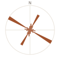 1. New York0.85
 2. Chicago0.84
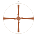 3. Beijing0.83
 4. Kyoto0.74
 5. San Francisco0.58
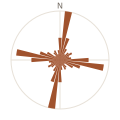 6. Mexico City0.56
 7. Washington0.54
 8. Montreal0.52
 9. Melbourne0.41
 10. Buenos Aires0.36
 11. Barcelona0.33
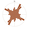 12. Los Angeles0.21
 13. Tours0.21
 14. Prague0.16
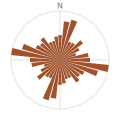 15. Versailles0.16
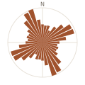 16. Nancy0.15
 17. Cape Town0.13
 18. Lyon0.13
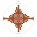 19. Rennes0.12
 20. Sydney0.12
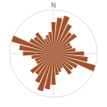 21. Munich0.12
 22. Athens0.11
 23. Stockholm0.11
 24. Madrid0.11
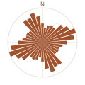 25. Edinburgh0.11
 26. Cairo0.10
 27. Marseille0.10
 28. Singapore0.10
 29. La Rochelle0.09
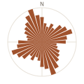 30. Marrakesh0.09
 31. Avignon0.08
 32. Saint Petersburg0.07
 33. Florence0.07
 34. Brussels0.07
 35. Amsterdam0.07
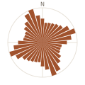 36. London0.07
 37. Le Havre0.07
 38. Angers0.07
 39. Grenoble0.06
 40. Geneva0.06
 41. Reims0.05
 42. Paris0.05
 43. Lille0.05
 44. Rome0.05
 45. Lisbon0.05
 46. Rouen0.05
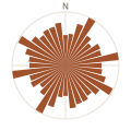 47. Berlin0.05
 48. Dublin0.04
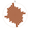 49. Saint-Étienne0.04
 50. Copenhagen0.04
 51. Brest0.04
 52. Tokyo0.04
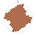 53. Dijon0.03
 54. Istanbul0.03
 55. Budapest0.03
 56. Nantes0.03
 57. Nice0.03
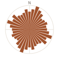 58. Venice0.02
 59. Bordeaux0.02
 60. Annecy0.02
 61. Montpellier0.02
 62. Vienna0.02
 63. Strasbourg0.01
 64. Toulouse0.01
The 25 French cities
| Rank in France | City | Orientation order | Reading | World rank |
|---|---|---|---|---|
| 1 | Tours | 0.205 | partial grid | 13th |
| 2 | Versailles | 0.158 | mixed pattern | 15th |
| 3 | Nancy | 0.155 | mixed pattern | 16th |
| 4 | Lyon | 0.132 | mixed pattern | 18th |
| 5 | Rennes | 0.123 | mixed pattern | 19th |
| 6 | Marseille | 0.096 | mixed pattern | 27th |
| 7 | La Rochelle | 0.094 | mixed pattern | 29th |
| 8 | Avignon | 0.080 | organic pattern | 31st |
| 9 | Le Havre | 0.068 | organic pattern | 37th |
| 10 | Angers | 0.066 | organic pattern | 38th |
| 11 | Grenoble | 0.058 | organic pattern | 39th |
| 12 | Reims | 0.054 | organic pattern | 41st |
| 13 | Paris | 0.051 | organic pattern | 42nd |
| 14 | Lille | 0.051 | organic pattern | 43rd |
| 15 | Rouen | 0.050 | organic pattern | 46th |
| 16 | Saint-Étienne | 0.044 | organic pattern | 49th |
| 17 | Brest | 0.041 | organic pattern | 51st |
| 18 | Dijon | 0.034 | organic pattern | 53rd |
| 19 | Nantes | 0.029 | organic pattern | 56th |
| 20 | Nice | 0.025 | organic pattern | 57th |
| 21 | Bordeaux | 0.020 | organic pattern | 59th |
| 22 | Annecy | 0.018 | organic pattern | 60th |
| 23 | Montpellier | 0.018 | organic pattern | 61st |
| 24 | Strasbourg | 0.013 | organic pattern | 63rd |
| 25 | Toulouse | 0.008 | organic pattern | 64th |
The full ranking
| Rank | City | Country | Orientation order | Reading | Grid | Streets measured |
|---|---|---|---|---|---|---|
| 1 | New York | United States | 0.853 | clear grid | tilted 28° east of north | 379 km |
| 2 | Chicago | United States | 0.844 | clear grid | aligned with north | 381 km |
| 3 | Beijing | China | 0.829 | clear grid | aligned with north | 320 km |
| 4 | Kyoto | Japan | 0.737 | clear grid | aligned with north | 448 km |
| 5 | San Francisco | United States | 0.576 | clear grid | tilted 9° west of north | 542 km |
| 6 | Mexico City | Mexico | 0.564 | clear grid | tilted 9° east of north | 587 km |
| 7 | Washington | United States | 0.542 | clear grid | aligned with north | 429 km |
| 8 | Montreal | Canada | 0.524 | clear grid | tilted 34° east of north | 373 km |
| 9 | Melbourne | Australia | 0.406 | partial grid | aligned with north | 548 km |
| 10 | Buenos Aires | Argentina | 0.356 | partial grid | tilted 2° west of north | 432 km |
| 11 | Barcelona | Spain | 0.329 | partial grid | tilted 42° west of north | 522 km |
| 12 | Los Angeles | United States | 0.208 | partial grid | tilted 30° east of north | 426 km |
| 13 | Tours | France | 0.205 | partial grid | tilted 9° west of north | 429 km |
| 14 | Prague | Czechia | 0.163 | mixed pattern | — | 412 km |
| 15 | Versailles | France | 0.158 | mixed pattern | — | 217 km |
| 16 | Nancy | France | 0.155 | mixed pattern | — | 337 km |
| 17 | Cape Town | South Africa | 0.135 | mixed pattern | — | 291 km |
| 18 | Lyon | France | 0.132 | mixed pattern | — | 467 km |
| 19 | Rennes | France | 0.123 | mixed pattern | — | 416 km |
| 20 | Sydney | Australia | 0.121 | mixed pattern | — | 370 km |
| 21 | Munich | Germany | 0.116 | mixed pattern | — | 374 km |
| 22 | Athens | Greece | 0.113 | mixed pattern | — | 736 km |
| 23 | Stockholm | Sweden | 0.108 | mixed pattern | — | 407 km |
| 24 | Madrid | Spain | 0.106 | mixed pattern | — | 565 km |
| 25 | Edinburgh | United Kingdom | 0.106 | mixed pattern | — | 370 km |
| 26 | Cairo | Egypt | 0.102 | mixed pattern | — | 717 km |
| 27 | Marseille | France | 0.096 | mixed pattern | — | 394 km |
| 28 | Singapore | Singapore | 0.096 | mixed pattern | — | 346 km |
| 29 | La Rochelle | France | 0.094 | mixed pattern | — | 340 km |
| 30 | Marrakesh | Morocco | 0.090 | mixed pattern | — | 326 km |
| 31 | Avignon | France | 0.080 | organic pattern | — | 366 km |
| 32 | Saint Petersburg | Russia | 0.074 | organic pattern | — | 318 km |
| 33 | Florence | Italy | 0.073 | organic pattern | — | 362 km |
| 34 | Brussels | Belgium | 0.072 | organic pattern | — | 551 km |
| 35 | Amsterdam | Netherlands | 0.069 | organic pattern | — | 549 km |
| 36 | London | United Kingdom | 0.068 | organic pattern | — | 527 km |
| 37 | Le Havre | France | 0.068 | organic pattern | — | 290 km |
| 38 | Angers | France | 0.066 | organic pattern | — | 357 km |
| 39 | Grenoble | France | 0.058 | organic pattern | — | 386 km |
| 40 | Geneva | Switzerland | 0.057 | organic pattern | — | 331 km |
| 41 | Reims | France | 0.054 | organic pattern | — | 398 km |
| 42 | Paris | France | 0.051 | organic pattern | — | 498 km |
| 43 | Lille | France | 0.051 | organic pattern | — | 453 km |
| 44 | Rome | Italy | 0.050 | organic pattern | — | 509 km |
| 45 | Lisbon | Portugal | 0.050 | organic pattern | — | 457 km |
| 46 | Rouen | France | 0.050 | organic pattern | — | 458 km |
| 47 | Berlin | Germany | 0.050 | organic pattern | — | 343 km |
| 48 | Dublin | Ireland | 0.045 | organic pattern | — | 400 km |
| 49 | Saint-Étienne | France | 0.044 | organic pattern | — | 357 km |
| 50 | Copenhagen | Denmark | 0.041 | organic pattern | — | 368 km |
| 51 | Brest | France | 0.041 | organic pattern | — | 339 km |
| 52 | Tokyo | Japan | 0.038 | organic pattern | — | 726 km |
| 53 | Dijon | France | 0.034 | organic pattern | — | 421 km |
| 54 | Istanbul | Türkiye | 0.032 | organic pattern | — | 292 km |
| 55 | Budapest | Hungary | 0.030 | organic pattern | — | 439 km |
| 56 | Nantes | France | 0.029 | organic pattern | — | 405 km |
| 57 | Nice | France | 0.025 | organic pattern | — | 410 km |
| 58 | Venice | Italy | 0.025 | organic pattern | — | 185 km |
| 59 | Bordeaux | France | 0.020 | organic pattern | — | 475 km |
| 60 | Annecy | France | 0.018 | organic pattern | — | 282 km |
| 61 | Montpellier | France | 0.018 | organic pattern | — | 465 km |
| 62 | Vienna | Austria | 0.016 | organic pattern | — | 473 km |
| 63 | Strasbourg | France | 0.013 | organic pattern | — | 383 km |
| 64 | Toulouse | France | 0.008 | organic pattern | — | 464 km |
Method
- Data: OpenStreetMap, read from the OpenFreeMap vector tiles (OpenMapTiles schema, zoom 13) that also draw our posters. Data version: October 11, 2026.
- Area measured: a circle of 3 km radius around each city's centre (coordinates in the CSV file), roughly what a city-centre poster frames.
- Streets counted: motorways, trunk roads, primary, secondary and tertiary roads, residential and access streets, pedestrian streets. Service roads (car parks, driveways), paths, cycleways, sidewalks, steps and railways are left out.
- Computation: each segment adds its length to the 10° bin of its bearing and to the opposite bin, 36 bins in all. The Shannon entropy of that distribution, H = −Σ pᵢ ln pᵢ, is ln 36 ≈ 3.584 when bearings are spread evenly and ln 4 ≈ 1.386 for a perfect grid. The orientation order φ = 1 − ((H − 1.386) / (3.584 − 1.386))² rescales it between 0 and 1.
- Grid rotation: the mean of the bearings multiplied by four, which folds a grid's four directions into one. It is only given for cities whose order is above 0.2: below that, there is no grid to rotate.
- Check: on five cities recomputed from the more detailed zoom 14 tiles, the orientation order moves by less than 0.005.
Differences from Geoff Boeing's study: we weight each segment by its length instead of counting segments, we measure a circle around the centre instead of the administrative boundaries, and we count pedestrian streets, which are many in old town centres.
Reference paper: Boeing, G. (2019). Urban spatial order: street network orientation, configuration, and entropy. Applied Network Science, 4(1), 67. https://doi.org/10.1007/s41109-019-0189-1
Limitations
- The result depends on the chosen centre and radius: a smaller circle around Barcelona would keep only the Eixample grid and give a higher order.
- Dual carriageways (boulevards, motorways) are counted twice, as they appear in the data.
- OpenStreetMap completeness varies by country; it is very good in the cities of this study, but not equal everywhere.
Frequently asked questions
Which city has the most grid-like streets?
Of the 64 cities measured by MaptoWall, New York has the most ordered network (orientation order 0.85 out of 1), ahead of Chicago (0.84) and Beijing (0.83). The measure covers streets within 3 km of the centre, from OpenStreetMap data.
Which French city has the most regular street plan?
Tours (0.21), ahead of Versailles (0.16) and Nancy (0.15), among the 25 French cities in the study. Toulouse is the least ordered (0.01). None reaches a clear grid: French cities mix districts from different eras and plans.
Why is Manhattan's street grid tilted?
The Commissioners' Plan of 1811 laid out the avenues parallel to the axis of Manhattan island, not to true north. Our measurement finds a grid tilted 28° east of north.
Why is the Paris street plan so disordered?
Haussmann's avenues are straight, but they run in every direction from star-shaped squares, over a medieval street pattern. Paris scores an orientation order of 0.05, 42nd of 64.
How do you measure how ordered a street network is?
Street length is split between 36 directions of 10°, and the entropy of that distribution is computed. Geoff Boeing's (2019) orientation order rescales it between 0, when bearings are spread evenly, and 1, for a perfect four-way grid.
Can I reuse this data?
Yes. The CSV file is published under the ODbL, like OpenStreetMap: credit MaptoWall and the OpenStreetMap contributors, and share derived databases under the same licence.
Reusing the data
The CSV file gives, for each city, the measured centre, the street length, the entropy, the orientation order, the grid rotation and the 36 shares of the histogram.
Licence: ODbL, like OpenStreetMap. Credit "MaptoWall, Street orientation, maptowall.com/en/etude/orientation-des-rues — data © OpenStreetMap contributors".
What about your city?
A grid, a star or a medieval maze: each street pattern makes a different poster. Create your city's poster and see its shape.