Sign up to receive a free poster

United States · 41.8781°, -87.6298°

Chicago Map Poster: The Grid Facing Lake Michigan
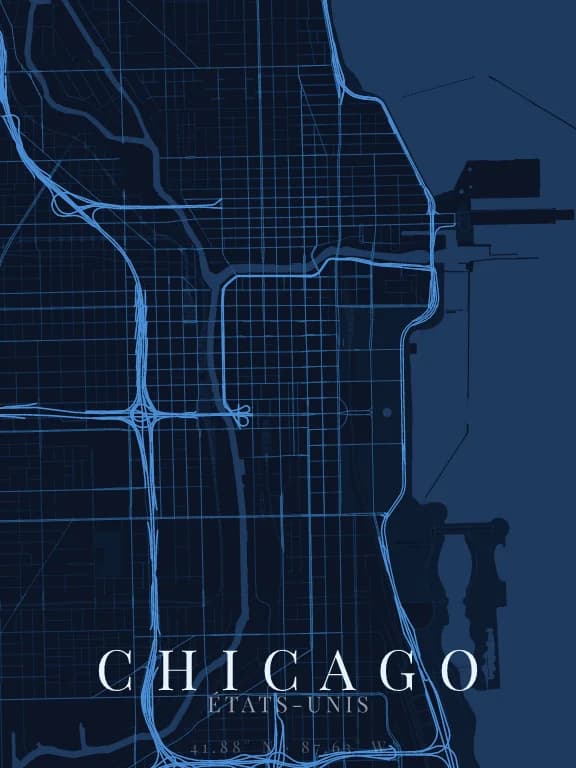
Map poster of Chicago (United States): streets, water and parks drawn from OpenStreetMap

Why this city works as a poster

Chicago is almost the opposite of an old city: a grid set on the cardinal points, regular for miles, cut only by a few diagonal avenues older than the grid itself. To the east, Lake Michigan sets a clean edge: half the poster can be water. The Y-shaped Chicago River crosses the centre and breaks the grid just enough to give it a starting point.

Recommended framing

Landscape, 6 to 8 km across, centred on the Loop: the lake on the right, the grid on the left, the river in the middle. Wider, the grid turns into a uniform weave; tighter, you lose the lake.

Which theme to pick

Fine, even linework serves the grid: a dark theme with light lines makes it almost textile. Water must stand apart from the background so the lake, which takes up a large part of the poster, does not read as empty space.

Where to centre the map

The Loop
The business core, hemmed in by the river and the elevated railway: the grid is densest here.
Chicago River
The river's Y, with its north and south branches: the only curve among the right angles.
Navy Pier
The pier jutting into the lake, a single stroke on the large void of water.

How its streets are oriented

Street orientation in Chicago: orientation order 0.84, clear grid0° (N) – 180° (S): 40.6% of street length10° (N) – 190° (S): 2.0% of street length20° (NNE) – 200° (SSW): 1.2% of street length30° (NNE) – 210° (SSW): 1.5% of street length40° (NE) – 220° (SW): 0.6% of street length50° (NE) – 230° (SW): 0.4% of street length60° (ENE) – 240° (WSW): 1.1% of street length70° (ENE) – 250° (WSW): 0.6% of street length80° (E) – 260° (W): 0.8% of street length90° (E) – 270° (W): 39.8% of street length100° (E) – 280° (W): 1.3% of street length110° (ESE) – 290° (WNW): 0.4% of street length120° (ESE) – 300° (WNW): 0.6% of street length130° (SE) – 310° (NW): 1.5% of street length140° (SE) – 320° (NW): 0.5% of street length150° (SSE) – 330° (NNW): 2.3% of street length160° (SSE) – 340° (NNW): 2.1% of street length170° (S) – 350° (N): 2.8% of street length180° (S) – 0° (N): 40.6% of street length190° (S) – 10° (N): 2.0% of street length200° (SSW) – 20° (NNE): 1.2% of street length210° (SSW) – 30° (NNE): 1.5% of street length220° (SW) – 40° (NE): 0.6% of street length230° (SW) – 50° (NE): 0.4% of street length240° (WSW) – 60° (ENE): 1.1% of street length250° (WSW) – 70° (ENE): 0.6% of street length260° (W) – 80° (E): 0.8% of street length270° (W) – 90° (E): 39.8% of street length280° (W) – 100° (E): 1.3% of street length290° (WNW) – 110° (ESE): 0.4% of street length300° (WNW) – 120° (ESE): 0.6% of street length310° (NW) – 130° (SE): 1.5% of street length320° (NW) – 140° (SE): 0.5% of street length330° (NNW) – 150° (SSE): 2.3% of street length340° (NNW) – 160° (SSE): 2.1% of street length350° (N) – 170° (S): 2.8% of street lengthNESW

Within 3 km of the centre, we measured the orientation of 381 km of streets. Its orientation order is 0.84 out of 1: Chicago ranks 2nd of the 64 cities in the study.

The streets follow a clear grid: two perpendicular directions carry most of the network. The main grid is aligned with north.

See the full study: street orientation in 64 cities

Other annotated cities