Sign up to receive a free poster

France · 47.2184°, -1.5536°

Nantes Map Poster: The Loire and the Île de Nantes
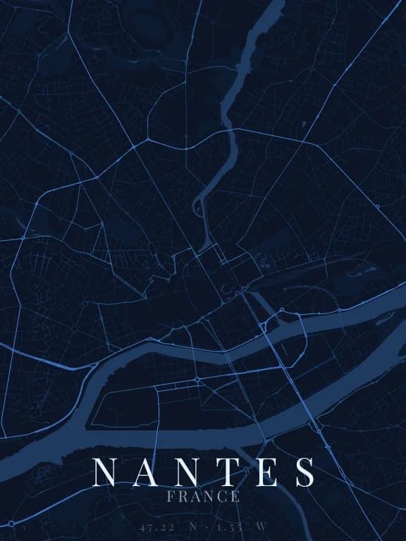
Map poster of Nantes (France): streets, water and parks drawn from OpenStreetMap

Why this city works as a poster

In Nantes the Loire splits into two arms around the Île de Nantes, nearly five kilometres long: on the map it draws a long spindle set in the middle of the river, a shape recognised at once. To the north, the Erdre reaches the centre as a long north-south line of water. The old centre still bears the trace of the arms of the Loire filled in during the twentieth century: the former Île Feydeau can still be read in the street pattern.

Recommended framing

Landscape, 7 to 8 km across, to hold the whole Île de Nantes and the arrival of the Erdre. A tighter frame cuts the island and loses what makes the map singular.

Which theme to pick

A theme that gives water a strong colour, distinct from the background: the Loire and its two arms carry the whole composition. On a theme where water blends into the background, the island disappears.

Where to centre the map

Île de Nantes
The spindle in the middle of the Loire, with its bridges: the poster's natural subject.
Château des ducs de Bretagne
Its moats draw a crisp fortified outline east of the old centre, legible at 1.5 km.
Erdre
North of the centre the river draws a continuous line of water: a frame shifted north brings it forward.

How its streets are oriented

Street orientation in Nantes: orientation order 0.03, organic pattern0° (N) – 180° (S): 3.5% of street length10° (N) – 190° (S): 4.2% of street length20° (NNE) – 200° (SSW): 4.9% of street length30° (NNE) – 210° (SSW): 5.2% of street length40° (NE) – 220° (SW): 5.8% of street length50° (NE) – 230° (SW): 5.5% of street length60° (ENE) – 240° (WSW): 9.1% of street length70° (ENE) – 250° (WSW): 7.0% of street length80° (E) – 260° (W): 5.7% of street length90° (E) – 270° (W): 4.0% of street length100° (E) – 280° (W): 4.5% of street length110° (ESE) – 290° (WNW): 4.8% of street length120° (ESE) – 300° (WNW): 5.2% of street length130° (SE) – 310° (NW): 5.8% of street length140° (SE) – 320° (NW): 5.2% of street length150° (SSE) – 330° (NNW): 9.3% of street length160° (SSE) – 340° (NNW): 4.9% of street length170° (S) – 350° (N): 5.4% of street length180° (S) – 0° (N): 3.5% of street length190° (S) – 10° (N): 4.2% of street length200° (SSW) – 20° (NNE): 4.9% of street length210° (SSW) – 30° (NNE): 5.2% of street length220° (SW) – 40° (NE): 5.8% of street length230° (SW) – 50° (NE): 5.5% of street length240° (WSW) – 60° (ENE): 9.1% of street length250° (WSW) – 70° (ENE): 7.0% of street length260° (W) – 80° (E): 5.7% of street length270° (W) – 90° (E): 4.0% of street length280° (W) – 100° (E): 4.5% of street length290° (WNW) – 110° (ESE): 4.8% of street length300° (WNW) – 120° (ESE): 5.2% of street length310° (NW) – 130° (SE): 5.8% of street length320° (NW) – 140° (SE): 5.2% of street length330° (NNW) – 150° (SSE): 9.3% of street length340° (NNW) – 160° (SSE): 4.9% of street length350° (N) – 170° (S): 5.4% of street lengthNESW

Within 3 km of the centre, we measured the orientation of 405 km of streets. Its orientation order is 0.03 out of 1: Nantes ranks 56th of the 64 cities in the study and 19th of the 25 French cities.

The streets run in almost every direction: no axis dominates, the pattern is organic.

See the full study: street orientation in 64 cities

Other annotated cities