Sign up to receive a free poster

Italy · 41.8986°, 12.4769°

Rome Map Poster: The Tiber, the Vatican and the Trident
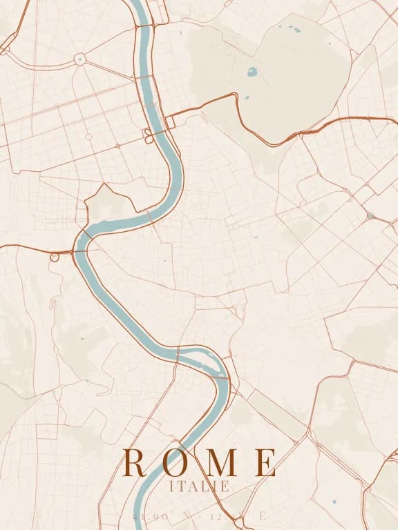
Map poster of Rome (Italy): streets, water and parks drawn from OpenStreetMap

Why this city works as a poster

Rome layers more than two thousand years of street plans, and the map shows it: at the heart, the Campus Martius is a tangle of lanes with no dominant direction, tucked into a bend of the Tiber. Around it, very crisp urban gestures stand out: the trident of Piazza del Popolo, three streets diverging from one square, and the elliptical colonnade of St Peter's across the river. The S-shaped Tiber ties it all together.

Recommended framing

About 5 km across, centred on the Pantheon, to hold both bends of the Tiber, the Vatican to the west and the Villa Borghese to the north-east. At 1.5 km, Piazza del Popolo or St Peter's Square alone become the subject of the poster.

Which theme to pick

A warm theme, ochre or terracotta, suits Rome, and it should distinguish parks: the Villa Borghese and the Janiculum balance the density of the centre. The narrow Tiber benefits from a clearly contrasting colour.

Where to centre the map

Piazza del Popolo
The trident: three straight streets fanning out to the south, a unique motif.
Saint-Pierre
The ellipse of the colonnade and the axis of Via della Conciliazione, very legible at 1 km.
Isola Tiberina
The only island in the Tiber in Rome: a small shuttle shape in the middle of the river.

How its streets are oriented

Street orientation in Rome: orientation order 0.05, organic pattern0° (N) – 180° (S): 6.8% of street length10° (N) – 190° (S): 3.9% of street length20° (NNE) – 200° (SSW): 3.5% of street length30° (NNE) – 210° (SSW): 4.2% of street length40° (NE) – 220° (SW): 6.6% of street length50° (NE) – 230° (SW): 6.0% of street length60° (ENE) – 240° (WSW): 4.6% of street length70° (ENE) – 250° (WSW): 10.4% of street length80° (E) – 260° (W): 4.2% of street length90° (E) – 270° (W): 5.7% of street length100° (E) – 280° (W): 4.5% of street length110° (ESE) – 290° (WNW): 4.0% of street length120° (ESE) – 300° (WNW): 3.2% of street length130° (SE) – 310° (NW): 6.9% of street length140° (SE) – 320° (NW): 6.8% of street length150° (SSE) – 330° (NNW): 4.9% of street length160° (SSE) – 340° (NNW): 9.4% of street length170° (S) – 350° (N): 4.3% of street length180° (S) – 0° (N): 6.8% of street length190° (S) – 10° (N): 3.9% of street length200° (SSW) – 20° (NNE): 3.5% of street length210° (SSW) – 30° (NNE): 4.2% of street length220° (SW) – 40° (NE): 6.6% of street length230° (SW) – 50° (NE): 6.0% of street length240° (WSW) – 60° (ENE): 4.6% of street length250° (WSW) – 70° (ENE): 10.4% of street length260° (W) – 80° (E): 4.2% of street length270° (W) – 90° (E): 5.7% of street length280° (W) – 100° (E): 4.5% of street length290° (WNW) – 110° (ESE): 4.0% of street length300° (WNW) – 120° (ESE): 3.2% of street length310° (NW) – 130° (SE): 6.9% of street length320° (NW) – 140° (SE): 6.8% of street length330° (NNW) – 150° (SSE): 4.9% of street length340° (NNW) – 160° (SSE): 9.4% of street length350° (N) – 170° (S): 4.3% of street lengthNESW

Within 3 km of the centre, we measured the orientation of 509 km of streets. Its orientation order is 0.05 out of 1: Rome ranks 44th of the 64 cities in the study.

The streets run in almost every direction: no axis dominates, the pattern is organic.

See the full study: street orientation in 64 cities

Other annotated cities